
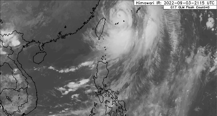
NAKALABAS na ng Philippine Area of Responsibility ang Typhoon Henry (international name: Hinnamnor) bagamat magdadala pa rin ito ng mga pag-ulan sa maraming bahagi ng bansa, ayon sa Philippine Atmospheric, Geophysical and Astronomical Services Administration (Pagasa).
Sa 5 a.m. update ng Pagasa, sinabi nito na tinanggal na rin ang lahat ng storm warning signal matapos mamataan si “Henry” 590 kilometro timog-timogsilangan ng Itbayat, Batanes habang gumagalaw sa bilis ng 15 kilometers per hour na may taglay na hangin na 150kph malapit sa gitna at pabugso na 185 kph habang patungong timog-kanluran.
“In the next 24 hours, the southwest monsoon (habagat)enhanced by this typhoon will also bring monsoon rains over the northern and western section of Northern Luzon and the western section of Northern and Central Luzon.” ayon sa Pagasa.
“Despite the lifting of Tropical Cyclone Wind Signals, the enhanced southwest monsoon, its convergence with the typhoon circulation, and the channeling of winds within the Luzon Strait will continue bringing strong winds (strong breeze to near gale strength) with gusts reaching gale-force strength at times over Batanes and Babuyan Islands today,” dagdag pa nito.
Magiging maulap na may kasamang manaka-nakang pag-ulan ngayong Lingo dahil sa buntot ng bagyo at habagat ang mananaig sa Metro Manila, Ilocos region, Batanes, Babuyan Islands, Abra, Benguet, Zambales, Bataan, Tarlac, Pampanga, Nueva Ecija, Bulacan, Cavite, Batangas, at Occidental Mindoro.
Ganito rin ang posibleng maranasan sa Davao at Soccsksargen sa MIndanao dahil naman sa intertropical convergence zone habang ang natitirang bahagi ng bansa ay magiging maulap na may pag-ulan dahil sa habagat at localized thunderstorm.