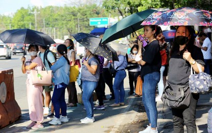
THE weather bureau forecast scorching temperatures across Luzon Wednesday as the ridge of a high-pressure area continues to affect the eastern section of Northern and Central Luzon.
Temperatures could reach up to 39 °C in Tuguegarao City and up to 35 °C in Metro Manila.
Kalayaan Islands, Puerto Princesa, Laoag, Tagaytay and Zamboanga’s temperatures could reach up to 34 °C.
The Philippine Atmospheric, Geophysical and Astronomical Services Administration (PAGASA) forecast the heat index, or what the temperature feels like to the human body when relative humidity is combined with air temperature, to reach 44 °C in Dagupan City, Pangasinan and Ambulong, Tanauan, Batangas; 43 °C in Bacnotan, La Union; Sangley Point, Cavite; Pili, Camarines Sur; Iloilo City and Dumangas, Iloilo; and Catarman, Northern Samar; and 42 °C in San Jose, Occidental Mindoro; Aparri, Cagayan; Tuguegarao, Cagayan; Echague, Isabela; Subic Bay, Olongapo; Virac, Catanduanes; and Tacloban City, Leyte.
PAGASA considers 41 °C to 51 °C heat index as danger level, wherein heat cramps and heat exhaustion are likely. Continued exposure to the sun could likely cause heat stroke.
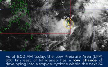
Meanwhile, PAGASA forecast the trough of a low pressure area (LPA) to bring scattered rain showers and thunderstorms over Davao Region and Soccsksargen.
Moderate to heavy rains in those areas could result in flash floods or landslides.
“The LPA is unlikely to develop into a tropical cyclone. However, its trough will affect the southeastern portion of Mindanao, causing high chances or rains and thunderstorms,” PAGASA forecaster Obet Badrina said.
There is a slim chance for the country to experience a tropical cyclone throughout the week, he added.
Badrina said the rest of the archipelago would experience isolated rain showers due to localized thunderstorms.
Light to moderate winds and slight to moderate seas continue to prevail across the country. (PNA) // Sunny graphics