

TROPICAL Depression Dindo has intensified into a tropical storm according to the latest bulletin of the Philippine Atmospheric, Geophysical, and Astronomical Services Administration (PAGASA) issued at 5 a.m. Monday.
Dindo with the international name Jongdari is not expected to impact the country directly and is seen to exit the Philippine area of responsibility (PAR) in the morning.
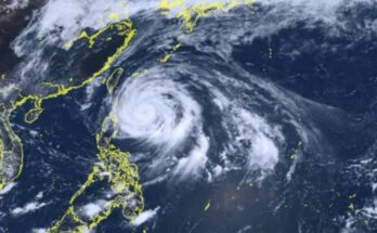
The center of the tropical storm was estimated based on all available data at 640 kilometers (km) northeast of Itbayat, Batanes.
It has maximum sustained winds of 65 km per hour (kph) near the center and gustiness of up to 80kph, while strong to gale-force winds extend outwards up to 320 km from the center. Dindo is moving northeastward at 10 kph.
No wind signal is hoisted in any part of the country and unlikely to directly affect the weather within the period.
Dindo, the fourth tropical cyclone to enter PAR for 2024, is forecast to move generally northward within the forecast period and exit PAR within the next six hours.
Outside the PAR region, Dindo will move over the East China Sea towards either the Korean Peninsula or the coast of eastern China, according to PAGASA.
The weather bureau added it will likely remain as a tropical storm within the forecast period. Intensification will also be limited outside the PAR region, with a potential for a weakening trend beyond the next 24 hours. (PNA)