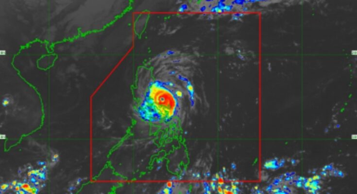
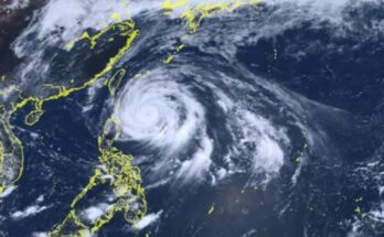
SUPER Typhoon Pepito’s life-threatening conditions continue over the eastern section of Southern Luzon as it moves over the sea east of the Bicol region, the weather bureau said.
Pepito (international name Man-yi) made its first landfall in the vicinity of Panganiban, Catanduanes Saturday night.
In its 5 a.m. bulletin, the Philippine Atmospheric, Geophysical and Astronomical Services Administration (PAGASA) said Pepito still packs maximum sustained winds of 185 kph near the center and gustiness of up to 255 kph.
It is located 85 km. northeast of Daet, Camarines Norte while moving west-northwestward at 15 kph.
Tropical Cyclone Wind Signal (TCWS) No. 1 is hoisted over the eastern portion of Polillo Islands (Patnanungan and Jomalig) and Calaguas Islands.
PAGASA warned that very strong winds of more than 185 kph may be expected in these areas in at least 12 hours.
The northeastern portion of Camarines Sur (Goa, San Jose, Tinambac, Siruma, Lagonoy, Presentacion, Caramoan, and Garchitorena), the rest of Camarines Norte, the northern and western portions of Catanduanes (Pandan, Bagamanoc, Panganiban, Viga, Caramoran, and San Andres), the northern portion of mainland Quezon (General Nakar and Infanta), the rest of Polillo Islands, the central and southern portions of Aurora (Dingalan, San Luis, Maria Aurora, Baler, Dipaculao, and Dinalungan), the eastern portion of Nueva Ecija (General Tinio, Gabaldon, Laur, Bongabon, Palayan City, Pantabangan, Rizal, and General Mamerto Natividad), the southeastern portion of Nueva Vizcaya (Alfonso Castañeda), and the southern portion of Quirino (Nagtipunan) are under TCWS No. 4.
Areas under TCWS No. 3 are the rest of Camarines Sur, the rest of Catanduanes, the northeastern portion of Albay (Santo Domingo, Polangui, Bacacay, Malilipot, City of Tabaco, Malinao, Rapu-Rapu, and Tiwi), the eastern portion of Quezon (Calauag, Guinayangan, Tagkawayan, Buenavista, Lopez, Quezon, Perez, Alabat, Gumaca, Plaridel, Atimonan, Mauban, Sampaloc, and Real), the eastern portion of Laguna (Santa Maria, Famy, Mabitac, Pakil, Pangil, Siniloan, Paete, Kalayaan, Lumban, and Cavinti), the eastern and central portions of Rizal (Pililla, Tanay, City of Antipolo, Rodriguez, Baras, San Mateo, Morong, and Teresa), the rest of Aurora, the eastern and central portions of Bulacan (Norzagaray, San Miguel, San Ildefonso, San Rafael, Doña Remedios Trinidad, Angat, City of San Jose del Monte, Santa Maria, Pandi, Baliuag, Bustos, Pulilan, and Plaridel).
The northeastern portion of Pampanga (Candaba, Arayat, Magalang, San Luis, San Simon, Mexico, Santa Ana, Apalit, Santo Tomas, City of San Fernando, Mabalacat City, and Angeles City), the rest of Nueva Ecija, Tarlac, the northern portion of Zambales (Santa Cruz, Candelaria, Masinloc, and Palauig), the rest of Nueva Vizcaya, the rest of Quirino, the southern portion of Isabela (San Agustin, Jones, Echague, San Guillermo, Angadanan, Alicia, San Mateo, Ramon, San Isidro, City of Santiago, and Cordon), the central and southern portions of Ilocos Sur (Alilem, Sugpon, Cervantes, Suyo, Tagudin, Narvacan, Quirino, Sigay, Gregorio del Pilar, San Emilio, Santa Cruz, Salcedo, Banayoyo, City of Candon, Galimuyod, Santa Lucia, Lidlidda, Santa Maria, Burgos, Santiago, San Esteban, and Nagbukel), La Union, Pangasinan, Benguet, Ifugao, the western portion of Mountain Province (Sabangan, Bauko, Tadian, Bontoc, Sagada, Besao, Sadanga, and Barlig), and the southern portion of Abra (Tubo, Luba, Pilar, Villaviciosa, and San Isidro) are also under TCWS No. 3
TCWS No. 2 was hoisted over Sorsogon, the rest of Albay, Ticao Island, Burias Island, the northern portion of Marinduque (Santa Cruz, Boac, Mogpog, and Torrijos), the rest of Quezon, the rest of Laguna, the rest of Rizal, Cavite, the northern portion of Batangas (City of Tanauan, Santo Tomas, Talisay, Lipa City, Malvar, Balete, Mataasnakahoy, Laurel, Padre Garcia, San Juan, and Rosario), Metro Manila, Bataan, the rest of Pampanga, the rest of Bulacan, the rest of Zambales, the southwestern portion of Cagayan (Enrile, Tuao, Solana, Tuguegarao City, Piat, and Rizal), the rest of Isabela, the rest of Abra, the southern portion of Apayao (Conner and Kabugao), Kalinga, the rest of Mountain Province, the rest of Ilocos Sur, and the southern portion of Ilocos Norte (Pinili, City of Batac, Banna, Nueva Era, Badoc, Currimao, Marcos, Solsona, Dingras, Sarrat, Paoay, Laoag City, and San Nicolas).
Areas in Luzon under TCWS No. 1 are the rest of Masbate, the rest of Marinduque, the northern portion of Romblon (Cajidiocan, San Fernando, Magdiwang, Romblon, Banton, Corcuera, Santa Maria, Concepcion, Odiongan, San Andres, Calatrava, and San Agustin), the northern and central portions of Oriental Mindoro (Puerto Galera, San Teodoro, Naujan, Baco, Victoria, Socorro, Pinamalayan, Bansud, Gloria, Pola, City of Calapan, and Bongabong), the northern and central portions of Occidental Mindoro (Sablayan, Santa Cruz, Mamburao, Abra de Ilog, and Paluan) including Lubang Islands, the rest of Batangas, the rest of mainland Cagayan, the rest of Apayao, and the rest of Ilocos Norte.
In the Visayas, Northern Samar, the northern portion of Samar (San Jorge, Matuguinao, Almagro, Calbayog, Pagsanghan, Gandara, Santo Niño, Tagapul-An, San Jose de Buan, Santa Margarita, and Tarangnan) and the northern portion of Eastern Samar (Maslog, San Policarpo, Dolores, Jipapad, Oras, and Arteche) are also under TCWS No. 1.
PAGASA said another landfall or close approach over Calaguas Islands is not ruled out as Pepito will move west-northwestward over the waters north of Camarines provinces Sunday morning.
“It will then pass close or over Polillo Islands by late (Sunday) morning, before making landfall over northern Quezon or central or southern Aurora between this noon and afternoon,” PAGASA said.
“Afterwards, Pepito will cross the northern portion of Central Luzon and the southern portion of Northern Luzon along the upland areas of Sierra Madre, Caraballo, and Cordillera Central between this afternoon and evening. Pepito will emerge over the coastal waters of Pangasinan or La Union tonight or tomorrow (Monday) early morning,” it added.
The weather bureau warned that heavy rainfall, severe winds, and storm surges may still be experienced in localities outside the landfall point and the forecast confidence cone.
It added that Pepito is forecast to slightly weaken as a typhoon over Aurora and significant weakening will occur during the passage of tropical cyclone over mainland Luzon on Sunday “but it will likely remain as a typhoon throughout its passage over mainland Luzon.”
Pepito may exit the Philippine Area of Responsibility by Monday morning or afternoon. (PNA)


