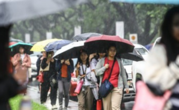
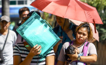
MORE areas were placed under Tropical Cyclone Wind Signal (TCWS) No. 3 as Typhoon Pepito (international name Man-yi) nears super typhoon category as it nears Southern Luzon and Eastern Visayas, PAGASA said in its 5 a.m. bulletin Saturday.
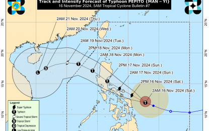
The typhoon is now packing maximum sustained winds of 175 kph near the center and gustiness of up to 215 kph. It was located 250 km. east-northeast of Borongan City, Eastern Samar as of 3 a.m., moving west-northwest at 25 kph.
TCWS No. 3 is hoisted over Catanduanes, the eastern portion of Albay (Rapu-Rapu, Bacacay, City of Tabaco, Malilipot, Tiwi, and Malinao), the eastern portion of Camarines Sur (Caramoan, Presentacion, San Jose, Garchitorena, Lagonoy, Sagñay, Tigaon, and Goa), and the easternmost portion of Sorsogon (Prieto Diaz) in Luzon; and the eastern portion of Northern Samar (Palapag, Laoang, Mapanas, Gamay, Lapinig, Catubig, and Pambujan), and the northernmost portion of Eastern Samar (San Policarpo, Arteche, Oras, and Jipapad) in the Visayas.
Storm-force winds will prevail in these areas.
TCWS No. 2 is hoisted over the rest of Camarines Sur, the rest of Albay, the rest of Sorsogon, Ticao Island, Camarines Norte, the easternmost portion of mainland Quezon (Tagkawayan), and Pollilo Islands in Luzon; and the northern portion of Eastern Samar (Dolores, Maslog, Can-Avid, Taft, Sulat, San Julian, and the City of Borongan), the northern portion of Samar (Matuguinao, Calbayog City, Santa Margarita, San Jorge, San Jose de Buan, Tarangnan, Motiong, Gandara, Jiabong, City of Catbalogan, Paranas, Hinabangan, San Sebastian, and Pagsanghan), and the rest of Northern Samar in the Visayas.
Gale-force winds will prevail in these areas.
TCWS No. 1 is hoisted over the rest of Masbate including Burias Island, Marinduque, Romblon, the rest of Quezon, Laguna, Rizal, Cavite, Batangas, Metro Manila, Zambales, Bataan, Bulacan, Pampanga, Tarlac, Nueva Ecija, Aurora, Quirino, Nueva Vizcaya, Isabela, the central and southern portions of Cagayan (Peñablanca, Tuguegarao City, Enrile, Solana, Iguig, Tuao, Rizal, Santo Niño, Lasam, Gattaran, Baggao, Amulung, Alcala, Piat, Lal-Lo, and Allacapan), Pangasinan, La Union, Ilocos Sur, Abra, the southern portion of Apayao (Conner, Kabugao, Pudtol, and Flora), Kalinga, Mountain Province, Ifugao, and Benguet in Luzon.
TCWS No. 1 is likewise hoisted over the rest of Eastern Samar, the rest of Samar, Biliran, the northern and central portions of Leyte (Tunga, Pastrana, San Miguel, Matag-Ob, Tolosa, Palo, Calubian, Leyte, Mayorga, Julita, Carigara, Babatngon, Dagami, Jaro, San Isidro, Santa Fe, Albuera, Villaba, La Paz, Palompon, Macarthur, Tabontabon, Tanauan, Merida, Ormoc City, Isabel, Dulag, Capoocan, Alangalang, Burauen, Tabango, Tacloban City, Kananga, Barugo, Abuyog, Javier, City of Baybay, and Mahaplag), the northeastern portion of Southern Leyte (Silago), the northernmost portion of Cebu (Daanbantayan, and Medellin) including Bantayan Islands, and the northernmost portion of Iloilo (Carles) in the Visayas; as well as on the northern portion of Dinagat Islands (Loreto and Tubajon) in Mindanao.
Strong winds will be experienced in these areas.
The Philippine Atmospheric, Geophysical and Astronomical Services Administration (PAGASA) said Pepito is more likely to make landfall in the vicinity of Catanduanes Saturday night or Sunday early morning.
However, considering the limits of the forecast confidence cone, a landfall scenario over the eastern coast of Camarines Sur, Albay, or Sorsogon during the same time frame, or along the eastern coast of Quezon or Aurora Sunday afternoon or evening is not ruled out, it said.
There is a high risk of life-threatening storm surge with peak heights exceeding 3 meters in the next 48 hours over the low-lying or exposed coastal localities of Eastern Samar, Northern Samar, Samar, Bicol Region, Marinduque, Quezon including Polillo Islands, Cavite, Batangas, Metro Manila, Central Luzon, Isabela, and Ilocos Region.
Pepito is expected to exit the Philippine Area of Responsibility on Monday. (PNA)


