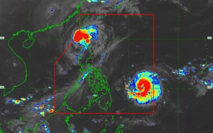
SEVERE Tropical Storm Pepito, which entered the Philippine Area of Responsibility (PAR) Thursday night, has intensified and is nearing the typhoon category, the weather bureau said Friday.
Pepito packs maximum sustained winds of 110 kph near the center and gustiness of up to 135 kph.
It was located 795 km. east of Guiuan, Eastern Samar as of 4 a.m.
Tropical Cyclone Wind Signal (TCWS) No. 1 is hoisted over Catanduanes, the eastern portion of Camarines Norte (Vinzons, Talisay, Daet, Mercedes, and Basud), the eastern portion of Camarines Sur (Caramoan, Garchitorena, Presentacion, San Jose, Lagonoy, Tinambac, Goa, Siruma, Tigaon, Sagñay, Calabanga, Naga City, Magarao, Bombon, Pili, Ocampo, Iriga City, and Buhi), the eastern portion of Albay (Rapu-Rapu, City of Tabaco, Malilipot, Santo Domingo, Bacacay, Legazpi City, Malinao, Manito, and Tiwi), and the eastern and southern portions of Sorsogon (Juban, City of Sorsogon, Barcelona, Bulusan, Magallanes, Gubat, Santa Magdalena, Casiguran, Bulan, Irosin, Matnog, Prieto Diaz, and Castilla).
Also under TCWS No. 1 are Northern Samar, the northern portion of Eastern Samar (San Policarpo, Arteche, Jipapad, Maslog, Oras, Dolores, and Can-Avid), and the northeastern portion of Samar (Matuguinao and San Jose de Buan).
Those areas will experience strong winds, the Philippine Atmospheric, Geophysical and Astronomical Services Administration (PAGASA) said in its 5 a.m. bulletin.
There is a moderate to high risk of life-threatening storm surge reaching 2 meters to 3 meters above normal tide levels in the next 48 hours over the low-lying or exposed coastal localities Camarines Sur, Catanduanes, Albay, Sorsogon, Northern Samar, Eastern Samar, and Samar.
Pepito is forecast to may make landfall over the eastern coast of Central and/or Southern Luzon during the weekend.
The cyclone could exit PAR on Monday, PAGASA said.
Meanwhile, Typhoon Ofel (international name Usagi) has weakened, packing maximum sustained winds of 120 kph near the center and gustiness of up to 150 kph.
As of 4 a.m., Ofel was located 100 km. northwest of Calayan, Cagayan.
TCWS No. 3 is hoisted over these areas due to Ofel: the western portion of Babuyan Islands (Calayan, Dalupiri, and Fuga Islands), the northwesternmost portion of mainland Cagayan (Claveria and Santa Praxedes), and the northernmost portion of Ilocos Norte (Pagudpud).
Areas under TCWS No. 2 due to Ofel are the rest of Babuyan Islands, the northwestern portion of mainland Cagayan (Sanchez-Mira, Pamplona, Abulug, and Ballesteros), the northern portion of Apayao (Calanasan, Luna, and Santa Marcela), and the northern portion of Ilocos Norte (Piddig, Bacarra, Adams, Dumalneg, Vintar, Bangui, Burgos, Pasuquin, and Carasi).
TCWS No. 1 is hoisted over Batanes, the rest of Cagayan, the northern portion of Isabela (Quezon, Cabagan, Santa Maria, San Pablo, Maconacon, Santo Tomas, Delfin Albano, and Tumauini), the rest of Apayao, Kalinga, the northern and central portions of Abra (Manabo, Pidigan, Tayum, Langiden, Boliney, Sallapadan, Bucloc, La Paz, Peñarrubia, Dolores, Bangued, Bucay, Daguioman, Lacub, Tineg, Lagayan, Licuan-Baay, Malibcong, San Juan, Lagangilang, and Danglas), the rest of Ilocos Norte, and the northern portion of Ilocos Sur (Sinait, Cabugao, San Juan, San Ildefonso, Magsingal, Santo Domingo, Bantay, and San Vicente).
Cagayan, Batanes, and Ilocos Norte could experience moderate to heavy rains due to Pepito and Ofel.
There is a high risk of life-threatening storm surge with peak heights of up to 3 meters in the next 48 hours over the low-lying or exposed coastal localities of Batanes, Ilocos Norte, Ilocos Sur, Cagayan including Babuyan Islands, and Isabela.
Ofel will cause up to very rough seas over the seaboards of Batanes, the Babuyan Islands, and the northern seaboards of Ilocos Norte and mainland Cagayan.
Ofel is forecast to exit the northwestern boundary of PAR on Friday afternoon, PAGASA said. (PNA)


