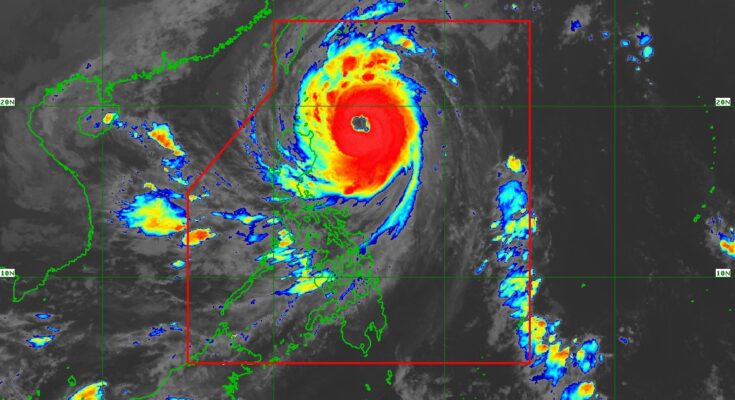
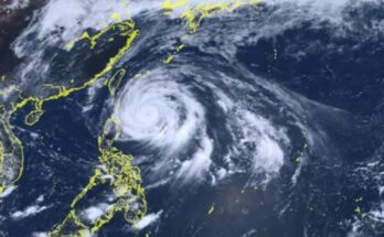
BATANES and the eastern portion of Babuyan Islands are now under Tropical Cyclone Wind Signal (TCWS) No. 3 as Typhoon Leon (international name Kong-Rey) continues to intensify, the weather bureau said Wednesday.
Strong to typhoon-force winds will prevail in those areas, the Philippine Atmospheric, Geophysical and Astronomical Services Administration (PAGASA) added.
Leon was tracked at 395 km. east of Calayan, Cagayan as of 4 a.m., according to PAGASA’s 5 a.m. bulletin.
The typhoon packs maximum sustained winds of 165 kph near the center and gustiness of up to 205 kph.
Gale-force winds will prevail in areas under TCWS No. 2: the rest of Babuyan Islands, Cagayan, the northern and eastern portions of Isabela (Santo Tomas, Santa Maria, Quezon, San Mariano, Naguilian, Dinapigue, Delfin Albano, San Pablo, Ilagan City, Benito Soliven, Tumauini, Cabagan, Palanan, Quirino, Divilacan, Gamu, Mallig, Maconacon, Burgos, City of Cauayan, San Guillermo, Angadanan, Cabatuan, Luna, Reina Mercedes, Roxas, Aurora, San Manuel), Apayao, Kalinga, the northern and eastern portions of Abra (Tineg, Lacub, Malibcong, Lagayan, San Juan, Lagangilang, Licuan-Baay, Daguioman), the eastern portion of Mountain Province (Paracelis), and Ilocos Norte.
TCWS No. 1 is hoisted over the rest of Isabela, Quirino, Nueva Vizcaya, the rest of Mountain Province, Ifugao, Benguet, the rest of Abra, Ilocos Sur, La Union, Pangasinan, Nueva Ecija, Aurora, the northeastern portion of Tarlac (Camiling, San Clemente, Paniqui, Moncada, Anao, San Manuel, Pura, Ramos, Victoria, Gerona, Santa Ignacia, City of Tarlac, La Paz), the northern portion of Bulacan (Doña Remedios Trinidad, San Miguel), the northern portion of Quezon (Infanta, General Nakar) including Polillo Islands, Camarines Norte, the northern portion of Camarines Sur (Siruma, Tinambac, Lagonoy, Garchitorena, Caramoan), and the northern and eastern portions of Catanduanes (Pandan, Gigmoto, Bagamanoc, Panganiban, Viga, Baras, Caramoran). Strong winds will prevail in these areas.
The typhoon would bring gusty winds over Bataan, Metro Manila, Calabarzon, Mimaropa, Bicol Region, most of the Visayas, and Dinagat Islands.
“There is a moderate to high risk of life-threatening storm surge reaching 2 to 3 meters above normal tide levels in the next 48 hours over the low-lying or exposed coastal localities of Batanes and Cagayan including Babuyan Islands,” said PAGASA.
Gale warning is still hoisted over the seaboard of Northern Luzon and the eastern seaboards of Central and Southern Luzon.
Sea travel is risky for all types of tonnage of vessels.
Meanwhile, PAGASA said Leon will be closest to Batanes on Thursday. A landfall in Batanes is not ruled out.
The typhoon is forecast to reach its peak intensity and could reach the super typhoon category during its closest point of approach to Batanes.
It is forecast to exit the Philippine Area of Responsibility on Thursday night or Friday, PAGASA said.
Meanwhile, veteran meteorologist and former PAGASA chief Dr. Prisco Nilo said the high-pressure area northwest of Leon is weakening, which means the probability of landfall over mainland Northern Luzon is low.
He said the closest approach to Batanes is about 130 km to the north at 8-9 p.m. Wednesday night still within sustained winds of over 100 kph.
“Heads up for 24hr rainfall ending at 12midnight today: Batanes, Cagayan, Babuyan Island – over 1.728 million cubic meters per sq. km. per day; Ilocos Norte, Apayao, Isabela, Occidental Mindoro, Antique – 0.864 to 1.728 million cubic meters per sq. km. per day; Ilocos Sur, Abra, Kalinga, Calamian Island, Romblon, Negros Occidental, Aklan – 0.432 to 0.864 million cubic meters per sq. km. per day,” he said.
He said rainwater will drain into streams, creeks, and rivers which may cause it to overflow and flood adjacent areas. (PNA)


